Antarctica Animals

There are no land animals that actually live in Antarctica! However, the surrounding oceans abound in living creatures! The seals that inhabit the oceans surrounding Antarctica can be seen pulling themselves out of the water and onto the ice to rest during feeding. Penguins (Emperors and Adelies) are the only birds that inhabit this frozen landscape. It's just too cold to support very many life forms! Below are pictures of and facts about Antarctica's animals.


Weddell Seal
Weddell Seal - the southernmost pinniped in the world. In what is known as reverse sexual dimorphism, males are generally smaller than females. A newborn pup has a coat of long hair, called lanugo, which they will shed within the first month as the protective layer of blubber is developed. Listen to a Weddell Seal underwater.


Orca Mom and Baby 
 Orcas - In the Antarctic, Killer whales live amid pack-ice, but they are said not to extend beyond the ice-line in the Arctic ocean. The Orca exhibits a great tolerance for varying temperatures. This is one of the reasons they enjoy a worldwide distribution.
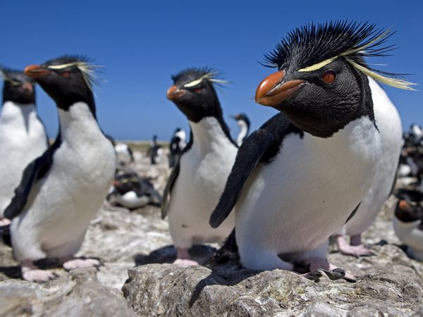


Rockhopper Penguins

Rockhopper Penguins - one of the more ornate penguins, the Rockhopper stands 16- to 18 inches tall and weighs about 5 to 6 pounds. It can be found on subantarctic islands. Its population numbers appear to be stable at about 3.5 million pairs! These birds shake their heads and cause their yellow eyebrows to fly into a "halo" in order to attract a mate!


Black Browed Albatross

Black-browed Albatross - distinguished by its distinctive combination of white head and neat black brow. The Black-browed albatross can have a wigspan of up to eight feet and can weigh up to 10 pounds! Black-browed albatrosses are the most widely distributed of all albatross species. Of all the albatross species they may face the greatest threats from fisheries.


Leopard Seal

Leopard Seal - named because of the colour patterns on its fur and its fierce nature, the Leopard seal is a fierce predator of it's favorite food - Adelie penguins. They can leap up onto the ice and quickly grab a penguin. They also feed on fish, krill, and squid. Unlike other phocid seals, the leopard seal uses its large fore-flippers while swimming (sea lion style).


Blue Whale

Blue Whale - named for its blue-gray color, this huge cetacean may grow to be roughly 100 feet long and weigh more that 120 tons! A blue whale eats about 4 tons of krill per day during the feeding season! This means that about 40 million krill are eaten every day for six months by a blue whale! The tongue of the blue whale can be as big as a Volkswagen! The blue whale is the loudest animal on earth! Hear the blue whale.


Adelie Penguin

Adelie Penguin - the Adelies courtship ceremony begins when the male drops a pebble at the feet of his intended. They begin to fight, but if the female is interested, the fight is very short. Once the mates have been selected, the males commence gathering more pebbles for thier nests. Adelie penguins make their nests out of rocks! Ouch!


 Antarctic Shag
  Antarctic Shag - primarily eats fish, which they catch by diving. The bill of the Antarctic Shag is serrated for grabbing and holding onto slippery fish! All four toes on this member of the Phalacrocoridae family point forward - a rarity among birds!


Crabeater Seal

Crabeater Seal - Crabeater seals are the most numerous pinniped species in the world and are curiously named since their major prey is not crabs but Antarctic krill! The seals have special lobed teeth that help them to sieve the krill out of the seawater. Crabeater seals have been known to dive as deep as 470 feet and for a period in excess of 10 minutes!


Wandering Albatross

Wandering Albatross - this species of albatross wanders the oceans for months at a time searching for food. It sleeps on the ocean surface at night and drinks seawater. The Wandering albatross is the largest bird in the world in terms of wing span - 11 feet! The Wandering albatross is endangered because of accidental killing of the bird on longlines.


Antarctic Fur Seal
Antarctic Fur Seal - tThe only eared seal in the Antarctic. Fur seals can be quite aggressive and it is wise to give them a wide berth, especially in the mating season! Within four years of their discovery in 1819, over 320,000 Fur seal pelts were taken from the South Shetland Islands. Today the Fur seals are making a rapid comeback and are regularly seen farther and farther south on the Antarctic Peninsula.


Emperor Penguin

Emperor Penguin - Emperor penguins, the biggest of the 17 penguin species, stand 3 to 4 feet tall and can weigh as much as 100 pounds! They are the only living species to reproduce during the harsh Antarctic winter. Without a nest, the male keeps the egg warm by holding it on his feet under an abdominal fold of skin for 2 months! Unbelievable! What a Dad!!


Elephant Seal

Southern Elephant Seal - largest of all pinnepeds. The elephant seal gets its name from the long, curved nose the male acquires around the age of three. The snout plays a significant role in the elephant seal's spectacular breeding ritual. By a process known as a catastrophic molt, elephant seals shed their coats every autumn, sloughing large pieces of hair and skin, and leaving the seal with a ragged and tattered appearance until it grows new, sleek fur!


Chinstrap Penguin 

Chinstrap Penguin - Chinstrap penguins are named for the narrow band of black feathers that extends from ear to ear. For nesting, they often select lofty sites that are the first to become snow-free, to ensure the maximum amount of time to raise their chicks. They are thought to be the most numerous penguin species with an estimated population of 12 to 13 million.


Ross Seal

Ross Seal - Ross Seals are very rarely seen because they live deep within the consolidated pack-ice. It is believed that Ross Seals feed mainly on squid and, to a lesser extent, fish and krill. They were named after the British polar explorer Sir James Ross, who first discovered them in 1840.


***********************************************************************************


What is The Climate like in Antarctica


Antarctica is a continent, bigger than either Europe,North America or Australia, an as such it doen't just have one climate zone , but several. As it is centred on the South Pole, the climates are cold, but there are distinct zones


Antarctic Circle


Fast Facts:

Size: 13,209,000 sq km, 5,100,021 sq miles
(varies due to changing ice shelves)
Percent of Earth's Land: 8.9%
Status Antarctica, almost 98% solid ice, was finally considered a continent in 1840, and not just a group of isolated islands. Today it has active territorial claims submitted by Argentina, Australia, Chile, France, New Zealand, Norway and the United Kingdom. (Many of these claims are not recognized by some countries and remain in a constant disputed status)
Capital City none
Climate Antarctica is the coldest and windiest spot on the planet. In fact, the lowest temperature ever recorded on Earth was recorded in Antarctica (-129.3ºF) and the mean winter temperatures range from -40º to -94ºF. Winds are commonly measured at up to 200 miles per hour.
Highest Point Vinson Massif at 16,066 ft. (4,897 m) (map)
Lowest Point Bentley Subglacial Trench, -2,555 m)
Latitude/Longitude 90° S, 0.00° E
Official Language none
Official Currency none
Population Officially none, but governmental research stations are populated with small groups of scientists at all times. In addition, during the 2009/2010 season, nearly 37,000 tourists visited the continent.

The Antarctic Circle is one of the five major circles (or parallels) of latitude that mark maps of the Earth. For 2012, it is the parallel of latitude that runs 66° 33′ 44″ (or 66.5622°) south of the Equator.

The area south of the Antarctic Circle is known as the Antarctic, and the zone immediately to the north is called the Southern Temperate Zone. The equivalent line of latitude in the northern hemisphere is the Arctic Circle.

Every place south of the Antarctic Circle experiences a period of twenty-four hours' continuous daylight at least once per year, and a period of twenty-four hours' continuous night time at least once per year. That is to say, there is at least one whole day during which the sun does not set, and at least one whole day during which the sun does not rise. On the Antarctic Circle these events occur, in principle, exactly once per year, at the December and June solstices respectively. This happens because the Earth's axis is tilted, by approximately 23.5 degrees, relative to ecliptic (the plane of the Earth's orbit around the sun). At the southern winter solstice, the southern hemisphere is tilted away from the Sun to its maximum extent, and the region of permanent darkness reaches its northern limit; at the southern summer solstice, the southern hemisphere is tilted towards the Sun to its maximum extent, and the region of permanent sunlight reaches its northern limit.

In practice several other factors affect the appearance of continuous day or night, the most important being atmospheric refraction, the altitude of the observer above sea level, mirages, and the fact that the sun is a sphere rather than a point. Mirages on the Antarctic continent tend to be even more spectacular than in Arctic regions, creating, for example, a series of apparent sunsets and sunrises while in reality the sun remains under the horizon.

Due to gradual changes in the tilt of the Earth's axis, the Antarctic Circle is slowly moving.

The globe of the Earth showing the Antarctic Circle at 66.5 degrees south of the equator.


Geography and demographics

The continent of Antarctica forms a land mass covering much of the area within the Antarctic Circle. There is no permanent human population on Earth south of the Antarctic Circle. There are, however, several Antarctic research centers from various nations that are inhabited by teams of scientists that rotate on a seasonal basis. In previous centuries, some semi-permanent whaling stations were established on the continent and some of the whalers would live there for a year or more. At least three children have been born in Antarctica, albeit in stations north of the Antarctic Circle

ANR Profile


About Me

A.Nageswara Rao, MSc., Ph.D.
Gelogist/Seismologist
NATIONAL GEOPHYSICAL RESEARCH INSTITUTE (NGRI)
Hyderabad


He has Participated as a scientist member of


24th Indian scientific expedition to Antarctica 2004 - 2006 as winter member (Maitri)


28th Indian scientific expedition to Antarctica 2008-2009 as a winter member (Maitri)


30th Indian scientific expedition to Antarctica 2010-2011 as a summer member (Maitri)


I stayed at Indian base station "MAITRI" for monitoring of Seismic activity and GPS Station.

"The expedition leader and Station commonder, (Dr. Rajesh Asthana) narrated that apart from his scientific duties he has involved in a many cultural activities  in Maitri. Being a popular singer, Table tennis player and having all sorts of cultural and devotional activities, he kept all the members active and alert. All the expedition members are very happy with him."

As per My opinion (Dr. Rao) Antarctica is a place of purity having zero pollution and it is natural laboratory for the scientists. It was a great opportunity for me to be there at ANTARCTICA in a prestigious Indian Antarctica Expeditions which were conducted by NCAOR, Goa and DOD/MOeS, New Delhi.

It is my duty to express a special thanks to the then Directors of NGRI for providing an opportunity to go to Antarctica for Scientific Studies.


Maitri


In the year 1989 a new permanent station "Maitri" was established. Maitri lies at the 'Schirmacher Region' of East Antarctica at the 70 deg. 45 min. 58 sec. S Latitude and 11 deg. 43 min. 56 sec. E Longitude. The area of Schirmacher Oasis is around 35 sq.km.


Auroras

AURORAS (North/South Polar Lights: or Aurorae, sing:Aurora) are natural colored light displays in the sky, usually observed at night, particularly inthe polar zone. They typically occur in the ionosphere. Some scientists call them "Polar Auroras". In northern latitudes, the effect is known as the "Aurora Borealis", named after hte Roman goddess of dawn, Aurora and the Greek name for north wind, Boreas.
It often appears as a greenish glow or sometimes a faint red, as if the sun was rising from an unusual direction. The Aurora Borealis is also called the northern polar lights, as it is only visible in the North Sky from the Northern Hemisphere. The Aurora Borealis most often occurs from September to October and from March to April. The Cree call this phenomenon the "Dance of the Spirits".
Its southern counterpart, the Aurora Australis/Southern Polar Lights, has similar properties. Australis is the Latin word for "of the South".
Benjamin Franklin first brought attention to the "Mystery of the Northern Lights". He theorized the shifting lights to a concentration of electrical charges in the polar regions intensified by the snow and the other moisture.
AURORAS are produced by the collision of charged particles from Earth,s magnetosphere, mostly electrons but also protons and heavier particles, with atoms and molecules of Earth,s upper atmosphere (at altitudes above 80 km). The particles have energies of 1 to 100 keV. They originate from the Sun and arrive at the vicinity of Earth in the relatively low-energy solar wind. When the trapped magnetic field of the solar wind is favourably oriented (principally southwards) it reconnects with Earth,s magnetic field and solar particles enter into the magnetosphere and are swept to the magneto-tail. Further magnetic reconnection accelerates the particles towards Earth.
The collision in the atmosphere electronically excite atoms and molecules in the upper atmosphere. The excitation energy can be lost by light emission or collisions. Most Auroras are GREEN and RED emission from atomic OXYGEN. Molecular NITROGEN and NITROGEN ions produce some low level RED and very high BLUE/VIOLET Aurorae. The light blue colors are produced by ionic nitrogen and the neutral nitrogen gives off the RED and PURPLE color with the rippled edges. Different gases interacting with the upper atmosphere will produce different colors, caused by the different compounds of OXYGEN and NITROGEN. The level of solar wind activity from the Sun can also influence the color of the Aurorae.


Sea Voyage - My Journey to Antarctica


T

My journey from Cape Town (South Africa) to Antarctica Shelf by M.V. Emerald Sea was great experience and thrilling. Especially, while crossing 40 degrees was panic and shivering experience in my life. The appearance of hundreds of Ice Bergs, Seals, Killer Whales, Sharks and especially the Penguins sitting on the Ice Bergs were the beauty of the journey.

Brief History of Antarctica


Ice Berg
Antarctica is the southernmost continent of the World. The land-based continent is the highest, driest, coldest and emptiest, place on the earth. Ice sheet covers all but 2.4% of Antarctica,s 14 million square kilometers. The ice-bound continent is roughly circular in shape, unbroken by sea and is surrounded by the Atlantic, Pacific and Indian Oceans. Antarctic a is divided into three parts called East Antarctica, West Antarctica and Antarctic Peninsula.

Antarctic ice sheet is one of the two polar ice caps of the Earth. It covers about 98% of the Antarctic continent and is the largest single mass of ice on Earth. It covers an area of almost 14 million square km and contains 30 million cubic km of ice. That is, approximately 61 percent of all fresh water on the Earth is held in the Antarctic ice sheet, an amount equivalent to 70 m of water in the world's oceans. In East Antarctica, the ice sheet rests on a major land mass, but in West Antarctica the bed can extend to more than 2,500 m below sea level. The land in this area would be seabed if the ice sheet were not there. There are Penguins and abundant sea life - but there are no Eskimos, or polar bears, which are found in the Arctic. The existence of Antarctica was only hypothesis until it was first sighted in 1820-21. No one set foot on the continent until 1895. Antarctica's history is packed full of heroic exploration and survival. No nation owns Antarctica. The Antarctica Treaty, which has been signed by 45 countries, reserves the area south of 60 degrees as a zone for the peaceful conduct of research. Treaty nations coordinate and cooperate to maximize research results and logistics requirements. This icy continent, much larger than India and China put together has been source of interest for the inquisitive minds for a long time. Remote and extreme, Antarctica is now emerging as an important key in the understanding of global and environmental concerns. Its unique features have provided scientists with special opportunities over the last 35 years to investigate the origin of the continents, the pollution of the globe and changes in World climate. Meteorology from from Antarctica have provided the factors that are essential in forecasting the weather patterns of the Southern Hemisphere and the circulation pattern of the World ocean system. The ice cores retrieved from the continent act as a repository of information on the paleoclimate and environmental history of the earth. It is clear that Antarctic science will increasingly contribute to our understanding of these and other global problems.

Antarctica the Icy Continent


ANTARCTICA- THE FROZEN CONTINENT- FIFTH LARGEST CONTINENT AMONG SEVEN CONTINENTS- Which is Windiest, Coldiest, Driest and Abnormal Continent.

Antarctica-South Pole

Antarctica-The South Pole -Bottom of  The Globe


Antarctica Surrounded by Atlantic, Pacific and Indian Oceans

At the bottom of the globe, almost hidden from our view lies ANTARCTICA- the continent surrounded on all sides by formidable ocean called Southern Ocean. Having remained 'Terra Incognita' for centuries, Antarctica, though dreamt andpostulated by great phoilophers and explorers of yore, continued to be a mystery to mankind until 1820, when Cap. Bellingshausen, a Russian explorer, had the first glimpse of the continent from a distance. Thereafter, for seventy five long years, the extraordinary forces of mother nature kept at bay the daring attempts of men to land on this continent. Finally, on 24 January 1895 Borchgrevink, a Norwagiean amateur scientist, succeeded in touching the ground at Cape Adare in Ross Sea area of East Antarctica, becoming the first human to land on the frozen continent.

Ice Cave

An Ice Cave opening on the surface of the ground for entering into the cave, which is situated near Maitri, Antarctica. This opening will be seen in Summer months only. This opening will be closed due to accumulation of ice by the blizzard activity and also due to freezing process in winter. 

Indian Antarctic Program


The Indian Antarctic Program is a multi-disciplinary, multi-institutional program under the control of the National Centre for Antarctic and Ocean Research, Ministry of Earth Sciences, Government of India. It was initiated in 1981 with the first Indian expedition to Antarctica.m The program gained global acceptance with India's signing of the Antarctic Treaty and subsequent construction of the Dakshin Gangotri Antarctic research base in 1983,superseded by the Maitri base from 1990. Under the program, atmospheric, biological, earth, chemical, and medical sciences are studied by India, which has carried out 30 scientific expeditions to the Antarctic as of 14th October 2010 and is currently planning to build an additional research station in the region named Bharathi and thus India is all set to join the elite group of nine countries which have multiple bases in Antarctica.

History
Col. Jatinder Kumar Bajaj, a member of one of the Indian expeditions to Antarctica, standing at the South Pole (January 17, 1989)

The origins of Indian missions to the Antarctic are traced to the joint Indian Space Research Organisation – Hydrometeorological Centre of Russia agreements, which led to Indians, such as Dr. Paramjit Singh Sehra, joining the 17th Soviet Antarctic expedition of 1971–1973.

As of April 2008, India had sent a total of 27 expeditions to the Antarctic. The 27th expedition—initiated on December 6, 2007 under the National Centre for Antarctic and Ocean Research (NCAOR)—was completed on 11 April, 2008. Scientists from over 20 scientific institutions participated in this expedition, which also probed the possibility of India's third permanent research station in Antarctic

The National Centre for Antarctic and Ocean Research—a research and development body functioning under the Ministry of Earth Sciences, Government of India—controls the Indian Antarctic program.The NCAOR and the Department of Ocean Development select the members for India's Antarctic expeditions.After medical tests and subsequent acclimatization training at the Himalayas, these selected members are also trained in survival, environment ethics, firefighting and operating in a group.

One expedition costs up to INR20 crore (US$4.4 million). Logistical support to the various activities of the Indian Antarctic program is provided by the relevant branches of the Indian armed forces. The launching point of Indian expeditions has varied from Goa in India to Cape Town in South Africa on 19th expedition during the time of NCAOR Founding Director Dr. P C Pandey in December 1999.Over 70 institutes in India contributed to its Antarctic program as of 2007.

Research

Antarctic holds scientific interest for global research projects due to a number of reasons: 'Origin of continents, climate change, meteorology and pollution' are among the reasons cited by S.D. Gad (2008). Mrinalini G. Walawalkar (2005) holds that: 'ice–ocean interaction and the global processes; paleoenvironment and paleoclimatic studies; geological evolution of earth and Gondwanaland reconstruction; Antarctic ecosystems, biodiversity and environment physiology; solar terrestrial processes and their coupling; medical physiology, adaptation techniques and human psychology; environment impact assessment and monitoring; enabling low temperature technology development; and studies on earthquakes' are among the areas of study under the Indian Antarctic program.

Close to 1,300 Indians had been to the continent as of 2001 as a part of the country's Antarctic program. Indian expeditions to the Antarctic also study the fauna and the molecular biodiversity of the region. A total of 120 new microbes had been discovered as a result of international scientific effort in the Antarctic by 2005. 20 of these microbes had been discovered by Indian scientists. India has also published over 300 research publications based on Antarctic studies as of 2007.

The 'ice cores' retrieved by drilling holes in Antarctic's vast ice-sheets yield information 'on the palaeoclimate and eco-history of the earth as records of wind-blown dust, volcanic ash or radioactivity are preserved in the ice as it gets accumulated over time'. The NCAOR developed a polar research & development laboratory with a 'low-temperature laboratory complex at –20°C for preservation and analysis of ice core and snow samples' according to S.D. Gad (2008). The 'ice core' samples are held, processed, and analyzed in containment units designed by such technology. Storage cases made of poly propylene also ensure that the samples do not alter characteristics and are preserved for analysis in the form that they were recovered

Indian Research Stations in Antarctica

Dakshin Gangotri

In 1981 the Indian flag unfurled for the first time in Antarctica, marking the start of Southern Ocean expeditions under the environmental protocol of the Antarctic Treaty (1959). The first permanent settlement was built in 1983 and named Dakshin Gangotri. In 1989 it was abandoned after it became buried in ice.

Maitri

The second permanent settlement, Maitri, was put up in 1988–89 on the Schirmacher Oasis and has been conducting experiments in geology, geography and medicine. India built a freshwater lake around Maitri known as Lake Priyadharshini. Maitri accomplished the mission of geomorphologic mapping of Schirmacher Oasis.

Bharathi (2012)

India has demarcated an area beside Larsmann Hill at 69°S, 76°E for its third settlement and second active research station. The survey has already been completed and the station is scheduled to be operational by 2012. When it is complete, India will enter the elite group of nine nations having multiple stations within the Antarctic Circle. Bharati is proposed for oceanographic research and will collect evidence of continental breakup to reveal the 120-million-year-old ancient history of the Indian subcontinent. In news sources this station is variously spelled "Bharathi", "Bharti" and "Bharati"

Geology of Antarctica


Geological history and paleontology

More than 170 million years ago, Antarctica was part of the supercontinent Gondwana. Over time, Gondwana gradually broke apart and Antarctica as we know it today was formed around 25 million years ago. Antarctica was not always cold, dry and covered in ice sheets. At a number of points in its long history it was farther north, experienced a tropical or temperate climate, was covered in forests, and inhabited by various ancient life-forms.

Paleozoic era (540–250 Ma)

During the Cambrian period, Gondwana had a mild climate. West Antarctica was partially in the Northern Hemisphere, and during this period large amounts of sandstones, limestones and shales were deposited. East Antarctica was at the equator, where sea floor invertebrates and trilobites flourished in the tropical seas. By the start of the Devonian period (416 Ma), Gondwana was in more southern latitudes and the climate was cooler, though fossils of land plants are known from this time. Sand and silts were laid down in what is now the Ellsworth, Horlick and Pensacola Mountains. Glaciation began at the end of the Devonian period (360 Ma), as Gondwana became centered around the South Pole and the climate cooled, though flora remained. During the Permian period, the plant life became dominated by fern-like plants such as Glossopteris, which grew in swamps. Over time these swamps became deposits of coal in the Transantarctic Mountains. Towards the end of the Permian period, continued warming led to a dry, hot climate over much of Gondwana.

Mesozoic era (250–65 Ma)

As a result of continued warming, the polar ice caps melted and much of Gondwana became a desert. In Eastern Antarctica, the seed fern became established, and large amounts of sandstone and shale were laid down at this time. Synapsids, commonly known as "mammal-like reptiles", were common in Antarctica during the Late Permian and Early Triassic and included forms such as Lystrosaurus. The Antarctic Peninsula began to form during the Jurassic period (206–146 Ma), and islands gradually rose out of the ocean. Ginkgo trees and cycads were plentiful during this period. In West Antarctica, coniferous forests dominated through the entire Cretaceous period (146–65 Ma), though Southern beech began to take over at the end of this period. Ammonites were common in the seas around Antarctica, and dinosaurs were also present, though only three Antarctic dinosaur genera (Cryolophosaurus and Glacialisaurus, from the Hanson Formation,and Antarctopelta) have been described to date.It was during this period that Gondwana began to break up.

Gondwanaland breakup (160–23 Ma)

The cooling of Antarctica occurred stepwise, as the continental spread changed the oceanic currents from longitudinal equator-to-pole temperature-equalizing currents to latitudinal currents that preserved and accentuated latitude temperature differences.

Africa separated from Antarctica around 160 Ma, followed by the Indian subcontinent, in the early Cretaceous (about 125 Ma). About 65 Ma, Antarctica (then connected to Australia) still had a tropical to subtropical climate, complete with a marsupial fauna. About 40 Ma Australia-New Guinea separated from Antarctica, so that latitudinal currents could isolate Antarctica from Australia, and the first ice began to appear. During the Eocene-Oligocene extinction event about 34 million years ago, CO2 levels have been found to be about 760 ppm and had been decreasing from earlier levels in the thousands of ppm. Around 23 Ma, the Drake Passage opened between Antarctica and South America, resulting in the Antarctic Circumpolar Current that completely isolated the continent. Models of the changes suggest that declining CO2 levels became more important. The ice began to spread, replacing the forests that then covered the continent. Since about 15 Ma, the continent has been mostly covered with ice, with the Antarctic ice cap reaching its present extension around 6 Ma.

Neogene Period (23–0.05 mya)

In 1986, Peter Webb and a team of paleontologists at Ohio State University discovered the remains of an extensive temperate forest that flourished 640 kilometres (400 mi) from the South Pole 3 million years ago.

Geology of present-day Antarctica

The geological study of Antarctica has been greatly hindered by the fact that nearly all of the continent is permanently covered with a thick layer of ice. However, new techniques such as remote sensing, ground-penetrating radar and satellite imagery have begun to reveal the structures beneath the ice.

Geologically, West Antarctica closely resembles the Andes mountain range of South America. The Antarctic Peninsula was formed by uplift and metamorphism of sea bed sediments during the late Paleozoic and the early Mesozoic eras. This sediment uplift was accompanied by igneous intrusions and volcanism. The most common rocks in West Antarctica are andesite and rhyolite volcanics formed during the Jurassic period. There is also evidence of volcanic activity, even after the ice sheet had formed, in Marie Byrd Land and Alexander Island. The only anomalous area of West Antarctica is the Ellsworth Mountains region, where the stratigraphy is more similar to the eastern part of the continent.

East Antarctica is geologically varied, dating from the Precambrian era, with some rocks formed more than 3 billion years ago. It is composed of a metamorphic and igneous platform which is the basis of the continental shield. On top of this base are various modern rocks, such as sandstones, limestones, coal and shales laid down during the Devonian and Jurassic periods to form the Transantarctic Mountains. In coastal areas such as Shackleton Range and Victoria Land some faulting has occurred.

The main mineral resource known on the continent is coal. It was first recorded near the Beardmore Glacier by Frank Wild on the Nimrod Expedition, and now low-grade coal is known across many parts of the Transantarctic Mountains. The Prince Charles Mountains contain significant deposits of iron ore. The most valuable resources of Antarctica lie offshore, namely the oil and natural gas fields found in the Ross Sea in 1973. Exploitation of all mineral resources is banned until 2048 by the Protocol on Environmental Protection to the Antarctic Treaty.

History of Antarctica


The history of Antarctica emerges from early Western theories of a vast continent, known as Terra Australis, believed to exist in the far south of the globe. The term Antarctic, referring to the opposite of the Arctic Circle, was coined by Marinus of Tyre in the 2nd century AD.

The rounding of the Cape of Good Hope and Cape Horn in the 15th and 16th centuries proved that Terra Australis Incognita ("Unknown Southern Land"), if it existed, was a continent in its own right. In 1773 James Cook crossed the Antarctic Circle for the first time but although he discovered nearby islands, he did not catch sight of Antarctica itself. It is believed he was as close as 150 miles from the mainland.

In 1820, several expeditions claimed to have been the first to have sighted Antarctica, with the very first being the Russian expedition led by Fabian Gottlieb von Bellingshausen and Mikhail Lazarev. The first landing was probably just over a year later when American Captain John Davis, a sealer, set foot on the ice.

The first Norwegian expedition to Antarctica was led by Captain Carl Anton Larsen aboard the barque Jason in 1892. During the expedition he was the first to discover fossils in Antarctica, for which he received the Back Grant from the Royal Geographical Society. In December 1893 he also became the first person to ski in Antarctica where the Larsen Ice Shelf was named after him. Larsen is also considered the founder of the Antarctic whaling industry and the settlement at Grytviken, South Georgia.

Once the North Pole had been reached in 1909, several expeditions attempted to reach the South Pole. Many resulted in injury and death. Norwegian Roald Amundsen finally reached the Pole on December 14, 1911, following a dramatic race with the Englishman Robert Falcon Scott.

Effects of global warming


Some of Antarctica has been warming up; particularly strong warming has been noted on the Antarctic Peninsula. A study by Eric Steig published in 2009 noted for the first time that the continent-wide average surface temperature trend of Antarctica is slightly positive at >0.05 °C (0.09 °F) per decade from 1957 to 2006. This study also noted that West Antarctica has warmed by more than 0.1 °C (0.2 °F) per decade in the last 50 years, and this warming is strongest in winter and spring. This is partly offset by fall cooling in East Antarctica.There is evidence from one study that Antarctica is warming as a result of human carbon dioxide emissions.However, the small amount of surface warming in West Antarctica is not believed to be directly affecting the West Antarctic Ice Sheet's contribution to sea level. Instead the recent increases in glacier outflow are believed to be due to an inflow of warm water from the deep ocean, just off the continental shelf.The net contribution to sea level from the Antarctic Peninsula is more likely to be a direct result of the much greater atmospheric warming there.

In 2002 the Antarctic Peninsula's Larsen-B ice shelf collapsed. Between 28 February and 8 March 2008, about 570 square kilometres (220 sq mi) of ice from the Wilkins Ice Shelf on the southwest part of the peninsula collapsed, putting the remaining 15,000 km2 (5,800 sq mi) of the ice shelf at risk. The ice was being held back by a "thread" of ice about 6 km (4 mi) wide,prior to its collapse on 5 April 2009. According to NASA, the most widespread Antarctic surface melting of the past 30 years occurred in 2005, when an area of ice comparable in size to California briefly melted and refroze; this may have resulted from temperatures rising to as high as 5 °C (41 °F)

Ice mass and global sea level


Due to its location at the South Pole, Antarctica receives relatively little solar radiation. This means that it is a very cold continent where water is mostly in the form of ice. Precipitation is low (most of Antarctica is a desert) and almost always in the form of snow, which accumulates and forms a giant ice sheet which covers the land. Parts of this ice sheet form moving glaciers known as ice streams, which flow towards the edges of the continent. Next to the continental shore are many ice shelves. These are floating extensions of outflowing glaciers from the continental ice mass. Offshore, temperatures are also low enough that ice is formed from seawater through most of the year. It is important to understand the various types of Antarctic ice to understand possible effects on sea levels and the implications of global warming.

Sea ice extent expands annually in the Antarctic winter and most of this ice melts in the summer. This ice is formed from the ocean water and floats in the same water and thus does not contribute to rise in sea level. The extent of sea ice around Antarctica has remained roughly constant in recent decades, although the thickness changes are unclear.

Melting of floating ice shelves (ice that originated on the land) does not in itself contribute much to sea-level rise (since the ice displaces only its own mass of water). However it is the outflow of the ice from the land to form the ice shelf which causes a rise in global sea level. This effect is offset by snow falling back onto the continent. Recent decades have witnessed several dramatic collapses of large ice shelves around the coast of Antarctica, especially along the Antarctic Peninsula. Concerns have been raised that disruption of ice shelves may result in increased glacial outflow from the continental ice mass.

On the continent itself, the large volume of ice present stores around 70% of the world's fresh water. This ice sheet is constantly gaining ice from snowfall and losing ice through outflow to the sea. West Antarctica is currently experiencing a net outflow of glacial ice, which will increase global sea level over time. A review of the scientific studies looking at data from 1992 to 2006 suggested that a net loss of around 50 gigatonnes of ice per year was a reasonable estimate (around 0.14 mm of sea level rise). Significant acceleration of outflow glaciers in the Amundsen Sea Embayment may have more than doubled this figure for 2006.

East Antarctica is a cold region with a ground base above sea level and occupies most of the continent. This area is dominated by small accumulations of snowfall which becomes ice and thus eventually seaward glacial flows. The mass balance of the East Antarctic Ice Sheet as a whole is thought to be slightly positive (lowering sea level) or near to balance. However, increased ice outflow has been suggested in some regions

Research stations of Antarctica


Each year, scientists from 28 different nations conduct experiments not reproducible in any other place in the world. In the summer more than 4,000 scientists operate research stations; this number decreases to just over 1,000 in the winter. McMurdo Station, which is the largest research station in Antarctica, is capable of housing more than 1,000 scientists, visitors, and tourists.

Researchers include biologists, geologists, oceanographers, physicists, astronomers, glaciologists, and meteorologists. Geologists tend to study plate tectonics, meteorites from outer space, and resources from the breakup of the supercontinent Gondwanaland. Glaciologists in Antarctica are concerned with the study of the history and dynamics of floating ice, seasonal snow, glaciers, and ice sheets. Biologists, in addition to examining the wildlife, are interested in how harsh temperatures and the presence of people affect adaptation and survival strategies in a wide variety of organisms. Medical physicians have made discoveries concerning the spreading of viruses and the body's response to extreme seasonal temperatures. Astrophysicists at Amundsen-Scott South Pole Station study the celestial dome and cosmic microwave background radiation. Many astronomical observations are better made from the interior of Antarctica than from most surface locations because of the high elevation, which results in a thin atmosphere, low temperature, which minimizes the amount of water vapour in the atmosphere, and absence of light pollution, thus allowing for a view of space clearer than anywhere else on Earth. Antarctic ice serves as both the shield and the detection medium for the largest neutrino telescope in the world, built 2 km (1.2 mi) below Amundsen-Scott station.

Since the 1970s, an important focus of study has been the ozone layer in the atmosphere above Antarctica. In 1985, three British Scientists working on data they had gathered at Halley Station on the Brunt Ice Shelf discovered the existence of a hole in this layer. It was eventually determined that the destruction of the ozone was caused by chlorofluorocarbons emitted by human products. With the ban of CFCs in the Montreal Protocol of 1989, it is believed that the ozone hole will close up by around 2065. In September 2006, NASA satellite data showed that the Antarctic ozone hole was the largest on record, covering 27.5 million km2 (10.6 million sq mi).

On 6 September 2007, Belgian-based International Polar Foundation unveiled the Princess Elisabeth station, the world's first zero-emissions polar science station in Antarctica to research climate change. Costing $16.3 million, the prefabricated station, which is part of International Polar Year, was shipped to the South Pole from Belgium by the end of 2008 to monitor the health of the polar regions. Belgian polar explorer Alain Hubert stated: "This base will be the first of its kind to produce zero emissions, making it a unique model of how energy should be used in the Antarctic." Johan Berte is the leader of the station design team and manager of the project which conducts research in climatology, glaciology and microbiology.

In January 2008, the British Antarctic Survey (BAS) scientists, led by Hugh Corr and David Vaughan, reported (in the journal Nature Geoscience) that 2,200 years ago, a volcano erupted under Antarctica's ice sheet (based on airborne survey with radar images). The biggest eruption in Antarctica in the last 10,000 years, the volcanic ash was found deposited on the ice surface under the Hudson Mountains, close to Pine Island Glacier.

Economy of Antarctica

Although coal, hydrocarbons, iron ore, platinum, copper, chromium, nickel, gold and other minerals have been found, they have not been in large enough quantities to exploit. The 1991 Protocol on Environmental Protection to the Antarctic Treaty also restricts a struggle for resources. In 1998, a compromise agreement was reached to place an indefinite ban on mining, to be reviewed in 2048, further limiting economic development and exploitation. The primary economic activity is the capture and offshore trading of fish. Antarctic fisheries in 2000–01 reported landing 112,934 tonnes.

Small-scale "expedition tourism" has existed since 1957 and is currently subject to Antarctic Treaty and Environmental Protocol provisions, but in effect self-regulated by the International Association of Antarctica Tour Operators (IAATO). Not all vessels associated with Antarctic tourism are members of IAATO, but IAATO members account for 95% of the tourist activity. Travel is largely by small or medium ship, focusing on specific scenic locations with accessible concentrations of iconic wildlife. A total of 37,506 tourists visited during the 2006–07 Austral summer with nearly all of them coming from commercial ships. The number is predicted to increase to over 80,000 by 2010.

There has been some concern over the potential adverse environmental and ecosystem effects caused by the influx of visitors. A call for stricter regulations for ships and a tourism quota has been made by some environmentalists and scientists. The primary response by Antarctic Treaty Parties has been to develop, through their Committee for Environmental Protection and in partnership with IAATO, "site use guidelines" setting landing limits and closed or restricted zones on the more frequently visited sites. Antarctic sight seeing flights (which did not land) operated out of Australia and New Zealand until the fatal crash of Air New Zealand Flight 901 in 1979 on Mount Erebus, which killed all 257 aboard. Qantas resumed commercial overflights to Antarctica from Australia in the mid-1990s